NOAA Link
822
WTNT31 KNHC 121757
TCPAT1
BULLETIN
Hurricane Florence Intermediate Advisory Number 53A
NWS National Hurricane Center Miami FL AL062018
200 PM EDT Wed Sep 12 2018
…FLORENCE’S PEAK WINDS HAVE DECREASED SLIGHTLY BUT THE SIZE OF THE
WIND FIELD HAS INCREASED…
…LIFE-THREATENING STORM SURGE AND RAINFALL EXPECTED ACROSS
PORTIONS OF THE CAROLINAS…
SUMMARY OF 200 PM EDT…1800 UTC…INFORMATION
———————————————-
LOCATION…30.4N 71.8W
ABOUT 435 MI…700 KM SE OF WILMINGTON NORTH CAROLINA
ABOUT 470 MI…755 KM ESE OF MYRTLE BEACH SOUTH CAROLINA
MAXIMUM SUSTAINED WINDS…125 MPH…205 KM/H
PRESENT MOVEMENT…NW OR 310 DEGREES AT 16 MPH…26 KM/H
MINIMUM CENTRAL PRESSURE…948 mb…27.99 inches
WATCHES AND WARNINGS
——————–
CHANGES WITH THIS ADVISORY:
None.
SUMMARY OF WATCHES AND WARNINGS IN EFFECT:
A Storm Surge Warning is in effect for…
* South Santee River South Carolina to Duck North Carolina
* Albemarle and Pamlico Sounds, including the Neuse and Pamlico
Rivers
A Storm Surge Watch is in effect for…
* Edisto Beach South Carolina to South Santee River South Carolina
* North of Duck North Carolina to the North Carolina/Virginia border
A Hurricane Warning is in effect for…
* South Santee River South Carolina to Duck North Carolina
* Albemarle and Pamlico Sounds
A Hurricane Watch is in effect for…
* Edisto Beach South Carolina to South Santee River South Carolina
A Tropical Storm Warning is in effect for…
* North of Duck North Carolina to the North Carolina/Virginia border
A Tropical Storm Watch is in effect for…
* North of the North Carolina/Virginia border to Cape Charles Light
Virginia
* Chesapeake Bay south of New Point Comfort
Interests elsewhere in the southeastern and mid-Atlantic states
should monitor the progress of Florence.
A Storm Surge Warning means there is a danger of life-threatening
inundation, from rising water moving inland from the coastline,
during the next 36 hours in the indicated locations. For a
depiction of areas at risk, please see the National Weather
Service Storm Surge Watch/Warning Graphic, available at
hurricanes.gov. This is a life-threatening situation. Persons
located within these areas should take all necessary actions to
protect life and property from rising water and the potential for
other dangerous conditions. Promptly follow evacuation and other
instructions from local officials.
A Storm Surge Watch means there is a possibility of life-
threatening inundation, from rising water moving inland from the
coastline, in the indicated locations during the next 48 hours.
A Hurricane Warning means that hurricane conditions are expected
somewhere within the warning area. A warning is typically issued
36 hours before the anticipated first occurrence of tropical-storm-
force winds, conditions that make outside preparations difficult or
dangerous. Preparations to protect life and property should be
rushed to completion.
A Hurricane Watch means that hurricane conditions are possible
within the watch area. A watch is typically issued 48 hours
before the anticipated first occurrence of tropical-storm-force
winds, conditions that make outside preparations difficult or
dangerous.
A Tropical Storm Warning means that tropical storm conditions are
expected somewhere within the warning area within 36 hours.
A Tropical Storm Watch means that tropical storm conditions are
possible within the watch area, generally within 48 hours.
For storm information specific to your area, including possible
inland watches and warnings, please monitor products issued by your
local National Weather Service forecast office.
DISCUSSION AND OUTLOOK
———————-
At 200 PM EDT (1800 UTC), reports from An Air Force Reserve
reconnaissance aircraft indicate that the center of the eye of
Hurricane Florence was located near latitude 30.4 North, longitude
71.8 West. Florence is moving toward the northwest near 16 mph
(26 km/h) and this general motion, accompanied by a gradual decrease
in forward speed, is expected to through Saturday. On the forecast
track, the center of Florence will move over the southwestern
Atlantic Ocean between Bermuda and the Bahamas today, and approach
the coast of North Carolina or South Carolina in the hurricane
warning area on Thursday and Friday and move slowly near the
coastline through Saturday.
The reconnaissance aircraft found that maximum sustained winds have
decreased to near 125 mph (205 km/h) with higher gusts. Florence is
now a category 3 hurricane on the Saffir-Simpson Hurricane Wind
Scale. Some fluctuations in strength will be possible through
Thursday morning. Although slow weakening is expected to begin by
late Thursday, Florence is still forecast to be an extremely
dangerous major hurricane when it nears the U.S. coast late Thursday
and Friday.
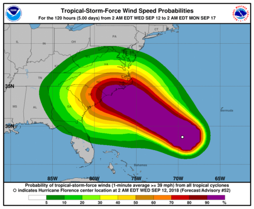
Hurricane-force winds extend outward up to 70 miles (110 km) from
the center and tropical-storm-force winds extend outward up to 175
miles (280 km). A NOAA buoy located about 100 miles northeast of
Florence’s eye recently reported a sustained wind of 53 mph (85
km/h) and a gust to 74 mph (119 km/h).
The minimum central pressure based on reports from the
reconnaissance aircraft is estimated to be 948 mb (27.99 inches).
HAZARDS AFFECTING LAND
———————-
STORM SURGE: The combination of a dangerous storm surge and the
tide will cause normally dry areas near the coast to be flooded by
rising waters moving inland from the shoreline. The water has the
potential to reach the following heights above ground if peak surge
occurs at the time of high tide…
Cape Fear NC to Cape Lookout NC, including the Neuse, Pamlico,
Pungo, and Bay Rivers…9-13 ft
North Myrtle Beach SC to Cape Fear NC…6-9 ft
Cape Lookout NC to Ocracoke Inlet NC…6-9 ft
South Santee River SC to North Myrtle Beach SC…4-6 ft
Ocracoke Inlet NC to Salvo NC…4-6 ft
Salvo NC to North Carolina/Virginia Border…2-4 ft
Edisto Beach SC to South Santee River SC…2-4 ft
The deepest water will occur along the immediate coast in areas of
onshore winds, where the surge will be accompanied by large and
destructive waves. Surge-related flooding depends on the relative
timing of the surge and the tidal cycle, and can vary greatly over
short distances. For information specific to your area, please see
products issued by your local National Weather Service forecast
office.
RAINFALL: Florence is expected to produce heavy and excessive
rainfall in the following areas…
Coastal North Carolina…20 to 30 inches, isolated 40 inches. This
rainfall would produce catastrophic flash flooding and significant
river flooding.
South Carolina, western and northern North Carolina…5 to 10
inches, isolated 20 inches.
Elsewhere in the Appalachians and Mid-Atlantic states…3 to 6
inches, isolated 12 inches.
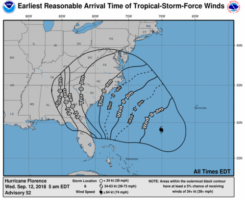
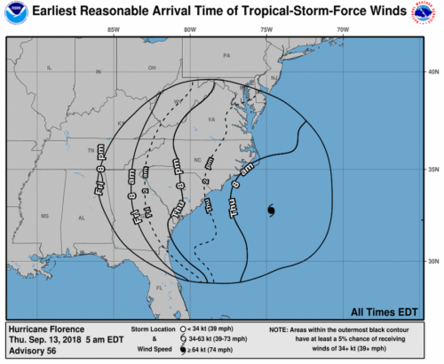
WIND: Hurricane conditions are expected to reach the coast within
the hurricane warning area late Thursday or Friday. Winds are
expected to first reach tropical storm strength on Thursday, making
outside preparations difficult or dangerous. Preparations to
protect life and property should be rushed to completion.
TORNADOES: A few tornadoes are possible in eastern North Carolina
beginning late Thursday morning.
SURF: Swells generated by Florence are affecting Bermuda, portions
of the U.S. East Coast, and the northwestern and central Bahamas.
These swells are likely to cause life-threatening surf and rip
current conditions. Please consult products from your local weather
office.
NEXT ADVISORY
————-
Next complete advisory at 500 PM EDT.

 British troops of the 6th Battalion, Durham Light Infantry chat with an American paratrooper of the 505th PIR in Avola, Sicily, July 11, 1943. (Wikimedia)