The Korean peninsula extends from the Asian mainland into the Pacific Ocean south and east, towards Japan. It’s sometimes referred to as the “Land of the Morning Calm”. However, that’s a misnomer; Korea’s history has been anything but calm. Korea has the misfortune to be located between three powerful and aggressive neighbors: Japan, China, and Russia. Add periodic internal strife, and throughout history Korea has seen substantially more than its fair share of war.
It’s a rugged, harsh, mountainous land. It’s bitterly cold in winter – think Great Plains/Great Lakes cold – and at times is Dixie hot and humid in summer. Other than its river valleys it has precious little flat land. Only about 30 percent of Korea’s land is arable.
A notable exception is the region extending from the Osan/Seoul/Pyongtaek area generally northwest past Panmunjom towards Pyongyang. This area includes the lower portion of the valleys of the Han and Imjin Rivers, as well as other reasonably (by Korean standards) open country. Though nowhere near Great Plains flat, the region is less mountainous than most of the rest of the peninsula. It’s one of the few such regions in either North or South Korea.
This region is called the Western Corridor. It is so named because the area has been the primary route of armies traveling north-to-south and south-to-north in Korea throughout history. The historical Korean capital, Seoul, sits square in the middle of the Western Corridor.
— — —
In the early/mid 1980s, there was still only one major road heading north from Seoul. This road went north to a town called Uijeongbu. Yes, that Uijeongbu – the town made famous in the book/movie/TV show MASH.
(Historical note: there really was a US MASH unit based at Uijeongbu during much of the Korean War. That unit was the 8055th MASH, to which the book’s author was assigned. The book/movie/TV show is based, presumably loosely, on his experiences at that unit. In the 1980s the 8055th’s old compound was still used by the Republic of Korea [ROK]Army. I ran or bicycled by that compound on occasion while I was a youngster stationed in the Uijeongbu area.)
At Uijeongbu, the road split. From Uijeongbu north toward Dongducheon and Camps Casey/Hovey/Castle/Nimble, the road was called MSR3 by US forces. It continued northward from there, crossing the 38th Parallel and passing through the towns of Jeongok-eup and Yeoncheon. The branch of the road from Uijeongbu west led past Third ROK Army (TROKA) HQ. It then joined another major route – called MSR1 by US forces – northwest towards Munsan-ri. On its way to Munsan-ri this road passed by Camp Howze.
The road did not end at Munsan-ri. It continued to the Imjin River, crossed to the north bank of the Imjin, and continued on to Panmunjom.
The bridge where the road crossed the Imjin was called Freedom Bridge. It was so named because it was the bridge across which POWs released at Panmunjom at the end of the Korean War crossed the Imjin on their way south to freedom.
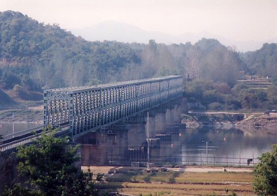
Freedom Bridge


